- Who We Are
- What We Do
- Our Issues
- Our Projects
- Sprawl Retrofit
- Highways to Boulevards
- CNU/ITE Manual
- Health Districts
- The Project for Code Reform
- Lean Urbanism
- LEED for Neighborhood Development
- Missing Middle Housing
- Small-Scale Developers & Builders
- Emergency Response
- HUD HOPE VI
- Rainwater in Context
- Street Networks
- HUD Finance Reform
- Affordable Neighborhoods
- Autonomous Vehicles
- Legacy Projects
- Build Great Places
- Education & Trainings
- Charter Awards
- Annual Congress
- Athena Medals
- Resources
- Get Involved
- Donate
- Membership
- Public Square


The design and planning of street networks has become a lost art in contemporary transportation studies. For the last sixty years, the focus of transportation has been on optimizing the performance of individual transportation links. Now, this is beginning to change. There is a growing awareness of the important role the street network plays in efficient and sustainable transportation performance and placemaking in a community.
Why are Street Networks Important?
Street Networks are the backbone upon which we build communities. Good street network designs reduce land consumption, provide greater accessibility through more direct routes, and increase overall network efficiency and reliability through added redundancy. They also affect several factors that relate to building more sustainable communities such as travel patterns, road safety, and public health.
Generally speaking, more compact and connected street networks tend to have significantly higher levels of people walking and biking and fewer vehicle miles traveled as compared to sparser, tree-like designs. Conventional thinking about road safety would suggest that communities with high levels of people who walk and bike would be more dangerous since, on average, active transportation modes experience a much higher fatality rate per mile traveled than driving. Interestingly, the very places with these high levels of walking and biking also turn out to be safer places to live. Recent research suggests that those living in more compact street network arrangements are not only four times more likely to walk or bike but also three times less likely to be involved in a fatal crash. Street networks that encourage more driving and decrease people's ability to walk, bike, or use other active transportation modes are also linked to obesity and other health problems such as diabetes.
While policies such as those related to Complete Streets are important, focusing on street-level solutions without considering the overall street network results in an incomplete city. Great street design, in isolation, is not enough. The expected benefits can only be realized in concert with great network design. Continuing to ignore this critical connection puts all of us in an untenable position when it comes to trying to build better communities.
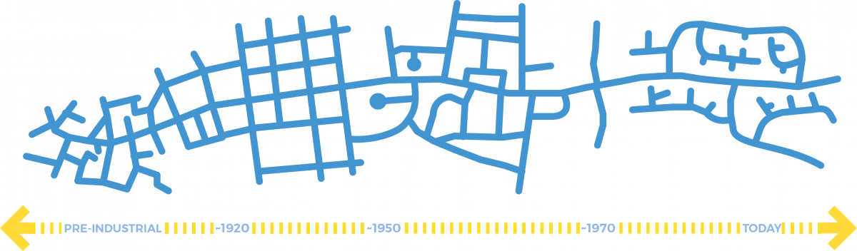
Evolution of Street Networks in America
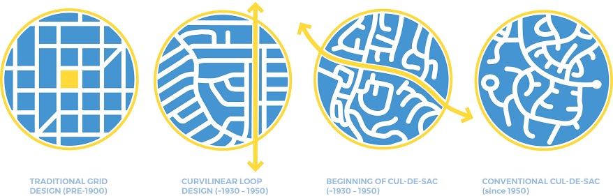
Beliefs regarding optimal configuration of streets upon which a city is built varied with culture and evolved with the times. The ancient Greeks and Romans built gridiron plans, while other parts of Europe gave rise to organic, meandering, medieval patterns that were eventually brought to the New World. During the Renaissance period, orthogonal, rectilinear networks reappeared and were later found in early US cities such as New Haven and Philadelphia. This trend continued into the early 1900s, and such networks accommodated the introduction of streetcars.
Street networks, while undergoing modifications throughout the years, retained one common similarity through this streetcar period: a compact and connected nature. After a few thousand years of building the bones of a city with this foundation, the advent of the automobile in the 1900s led to a paradigm shift and a complete overhaul of how we lay out our communities. This new transportation paradigm focused on vehicular mobility and emphasized a hierarchical approach to road typology.
Why Did This Switch to a Less Connected Network Occur?
While there were several contributing factors, the U.S. Federal Housing Agency (FHA) was at the forefront of this movement away from the traditional grid system. The FHA believed the grid layout to be:
- Monotonous
- Lacking in character
- Uneconomical
- Unsafe
The FHA formally endorsed hierarchical street layouts with cul-de-sacs. The 1938 FHA Technical Bulletin No. 7 for Planning Profitable Neighborhood stated, "We should discourage through traffic" and "short blocks are not economical." The FHA was responsible for providing both mortgages & mortgage insurance, and they used the above standards when reviewing subdivision plans and making recommendations. This lead to the FHA playing a role in over 22 million properties before 1960.
In the 1950's, transportation engineers began recommending designs based upon street hierarchy, cul-de-sacs, and the FHA criteria for a profitable neighborhood. However, little research was conducted in support of these suggested design principles. One influential study from 1957, "Subdividing for Traffic Safety," looked at 5 years of crash data in 76 residential neighborhoods of LA. The study found that 8 times more crashes occurred on gridded streets and 14 times more crashed occurred at 4-way intersections than T-intersections. Despite still being cited today as a reason against gridded networks, this study failed to account for several critical factors such as street network density, street patterns, crash severity, and crash migration.
Nevertheless, transportation engineers followed suit and soon began officially endorsing hierarchical street network design. In 1985, the Institute of Transportation Engineers (ITE) published "Recommended Practice for Subdivision Streets," which discouraged traditional compact and connected neighborhood designs in favor of:
- Curvilinear designs
- Replacing 4-way stops with T-intersections
- Cul-de-sacs
So Who Designs Street Networks?
Unfortunately, in most cases, the answer is nobody. In the U.S. and most other countries, most street networks are not specifically designed. Rather, they are the result of decisions made by parties such as transportation departments, zoning laws, and individual developers. These parties usually do not use guiding principles to determine the outcome, often yielding an unattractive, inefficient, and unsafe hodgepodge of streets.
Characterizing the Street Network
Many possible variations in street networks exist today, and subtle differences can have huge impacts. Despite the extreme complexity of network types, street networks can generally be characterized through a combination of:
- Shape and configuration
- The scale of the network
- The connectivity of the streets
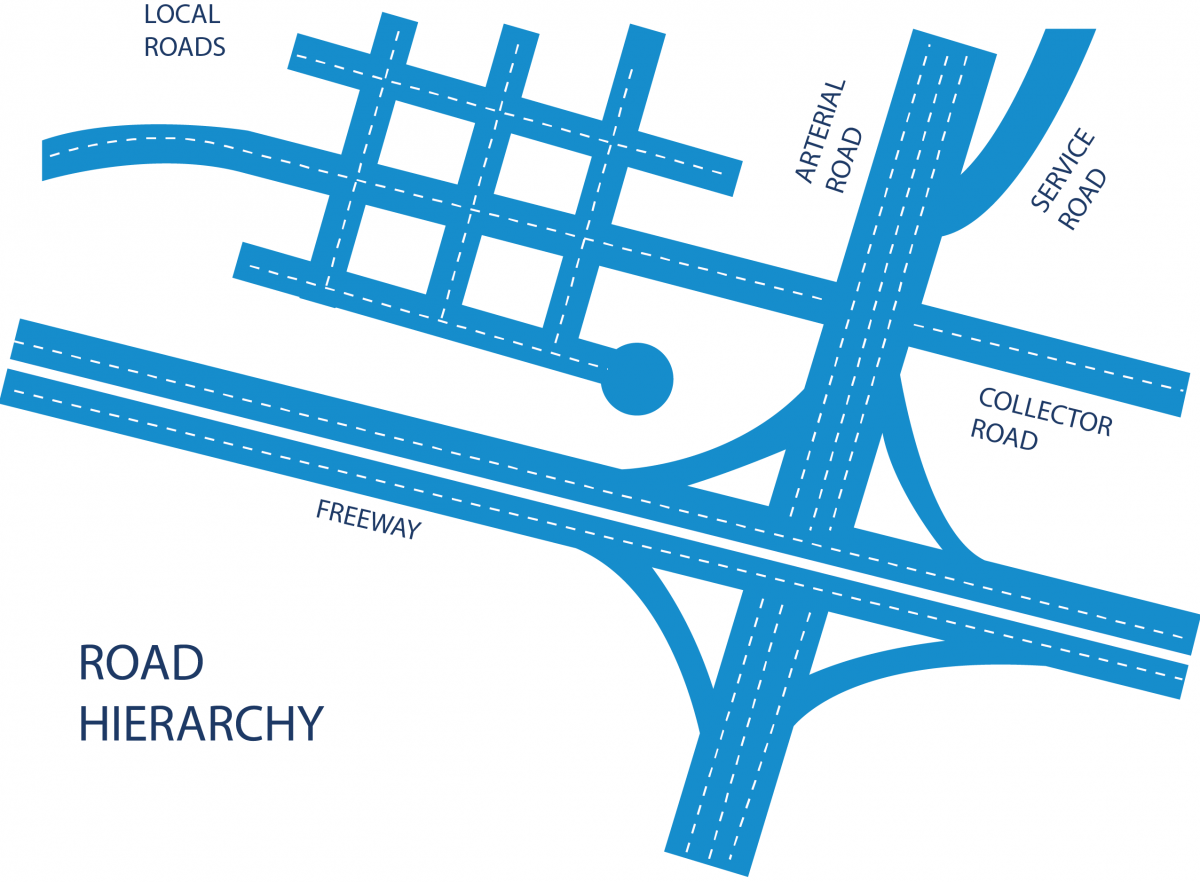
In terms of shape and configuration, the two main network typologies tend to be either gridded or tree-like. However, there are an infinite number of possibilities, and some common examples are:
Street Connectivity & Intersection Density
To measure the scale and connectivity of street networks, researchers tend to use variables such as intersection density and the link to node ratio. Intersection density is a measure of network compactness, and the link to node ratio is a measure of network connectivity. Oftentimes, intersection density is used when attempting to measure street connectivity; however, a compact network is not necessarily connected and vice versa.
You can calculate intersection density thusly:
- Intersection Density = Total number of intersections including dead ends / Area in square miles
You can calculate the link to node ratio as follows:
- Link to Node Ratio = Total number of road segments between intersections / Total number of intersections including dead ends
Most researchers and practitioners use a score of 1.4 as the threshold of high street connectivity, with higher values indicating better connectivity.
Research-Informed Best Practices
Given the wide variation in successful street network patterns, it is hard to be prescriptive about the optimal form and configuration of the network. However, there are a number of design patterns that widely admired networks have in common, and such elements can serve as guiding principles.
Good patterns of urban street networks include:
- Create a network consisting of a diverse set of urban street types
- Create a human-scale network with a dense pattern of streets and intersections
A Network of Urban Streets
The most important function of a good street network is that it forms an effective and flexible framework for building a community. The network should provide opportunities for commercial hustle and bustle, as well as opportunities for quiet living, and should also have a host of variations in the middle. The streets in the network should be designed to accommodate this range of desired outcomes. Some streets should be designed to attract all modes of travel, including vehicles and people who walk, bike, etc., while others should be designed to be very quiet and only see the occasional vehicle or person walking. This range of performance is achieved by having variations both in the design of the network and the design of the streets themselves. However, all streets in an urban network should have the character of urban facilities accommodating urban land use patterns and catering to pedestrians.
The amount and types of connections in the network are key factors in determining both how the community functions and the character of the individual streets themselves. Most streets in a good street network should connect at both ends. A high level of connectivity provides an efficient template for dispersing traffic, facilitating route choice, and creating a more comfortable condition for people who travel by foot, bike, or transit.
Human-Scale Networks
Good street networks need to be attractive and convenient to pedestrians and serve as good templates for development. This is achieved by ensuring that there is a fine grain of pathways and connections in the network. American street network intersection densities typically range from as little as 60 intersections per square mile (one example is the street network in downtown Salt Lake City) to more than 500 (such as the network in downtown Portland, OR). Smaller blocks (or more intersections per square miles) are typically much more comfortable for pedestrians, providing more direct paths to destinations and generally creating the template for a more human scale environment.
The context is often different when trying to understand international cities where human scale tends to be more prevalent and historical structures more influential; however, the fact that a person walking still responds well to human scale design is nearly universal. This idea of a more human scale environment also relates to the idea that we should be trying to build places where people enjoy spending time. When you close your eyes and think about the types of urban places where you love to spend time, consider the sort of street networks that support the places you are picturing. Of course everyone might not be able to have access to a beach or a picturesque view of the mountains; however, everyone should have safe places to walk, safe places to ride bikes, and safe places to drive.
Focusing on designing communities with streets and street networks that work together and are purposefully designed to evoke such positive emotions can be can a fundamental step in the right direction. Good street network design can better support a community with people who drives less, participate more in active transportation, and live healthier lifestyles – both in terms of road safety impacts as well as obesity-related health outcomes.
References
Hamblin, J. (2014, August 13). The Atlantic. Retrieved September 16, 2015, from TheAtlantic.com.
Marshall, W. E., & Norman W. Garrick. (2009). Street Network Types and Road Safety: A Study of California Cities. N/A: Urban Design International.
Wesley E. Marshall, Garrick, N., and Marshall, S. “Street Networks” in International Handbook on Transport and Development by Editors R. Hickman, D. Bonilla, M. Givoni, and D. Banister, Edward Elgar Publishing, 2014 (accepted).