Dissolving border vacuums, part 3


In the last couple of posts we looked at solutions for at-grade border vacuums, so now let's move on to sunken border vacuums, like highway and railroad ditches! Over the coming months we'll examine solutions for other kinds of border vacuums and see if they could apply to Baltimore.

The vicinity of Penn Station in 1917.
The rise of “Chinese walls”
During the Industrial Revolution many cities discovered that the railroad was a mixed blessing: although they brought overall prosperity, railroad tracks tended to form downtrodden “Chinese Walls” wherever they passed through cities. If land was scarce and “air rights” valuable, it was possible to tunnel or deck over railroad tracks. But for the most part, and unlike many of their European counterparts, many American cities never really bothered to confront the border vacuums that railroad tracks caused – the phrase “the other side of the tracks” is arguably a lasting relic of our failure to address the vacuum effect of the railroad track. Unfortunately a century later this scenario would only repeat itself when highways were rammed through urban neighborhoods.

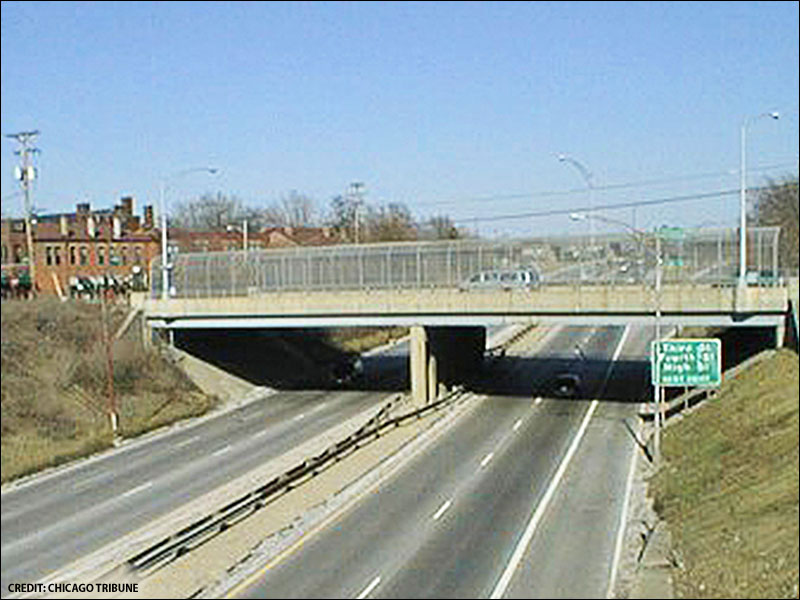
Who would want to walk here unless they had no choice
Now that urban railroad and highway corridors are a fait accompli, is there any way to fix their border vacuums? Some cities buried these corridors in tunnels (i.e. Boston's Big Dig), but such fantastically expensive solutions are increasingly impractical. Other cities resorted to “it's the thought that counts” gestures, like the pedestrian bridge to the left, but these gestures didn't address the border vacuum problem at all. Fortunately, I think there's a feasible middle ground between “expensive and elaborate” and “cheap and useless.” To keep things reasonably concise, this post will only discuss solutions for sunken railroad and highway corridors – we'll get to their elevated corridors in the next post.
Building caps
Existing ditches can be covered with concrete caps (aka decks, lids, platforms, covers, etc.), and, depending on their structure/reinforcement, the reclaimed space atop the caps can be used for buildings and/or parks.
However, extensive caps require ventilation systems, just like tunnels. And although highway and railroad caps are quite useful in places where development demand is strong and land value is high, they are still impractical in places with weak development demand. For example, it may be feasible to cap Philadelphia's Vine Street Expressway to aid the spread of revitalization northward from Center City, but it's unlikely that the Highway to Nowhere will be capped any time in the foreseeable future. After a half-century of economic depression in West Baltimore, it's now even less feasible to cap the highway as originally proposed.
Although it probably isn't economically feasible to build caps over the JFX segment from Preston to Chase Streets either, it might be possible to build them over the JFX/NEC segment from Maryland to Guilford Avenues. I think a cap might initially be viable only in the section immediately south of Penn Station (i.e. between Charles and St. Paul Streets), given the recent construction of the adjacent UB Law Center and the continued interest in infilling the parking lot to the north of the station. In time, perhaps additional adjacent caps (such as the section between St. Paul and Calvert Streets – which already has the Railway Express Building precedent – followed by the sections from Calvert to Guilford and Charles to Maryland) would become viable, further improving Station North's connection to Midtown.
Building bridge liners
If full caps aren't feasible, it may instead be possible to build bridge liners – lines of mixed-used buildings on both sides of a bridge. Bridge liners have been around for centuries, but they're a relatively rare feature in modern infrastructure projects, so I think they deserve a closer look.

The Cap at Union Station in Columbus, OH.
Since bridge liners don't require ventilation systems like extensive caps or tunnels, they're often much cheaper to build. For example, Columbus' Cap at Union Station, which connects the city's Short North neighborhood to the downtown, cost less than $10 million – the city/state paid just under $2 million for the bridge and the developer contributed another $7.5 million for the liner buildings, and the Cap is now profitable.
Columbus' Short North neighborhood has much in common with Station North: Both lie just to the north of their respective city's downtown (if, for the sake of argument, we lump Midtown and Mt. Vernon in with downtown, since they're seamlessly contiguous). Both neighborhoods are separated from downtown by highway/railroad corridors (but, unlike Baltimore, Columbus lost rail service in its corridor, hence their naming the Cap after a lost icon, Union Station). Both neighborhoods contain similar urban fabric – midrise apartment and commercial buildings, rowhouses, and industrial buildings. Finally, and most unfortunately, both neighborhoods sank into dereliction and street crime after WWII.
The same overpass before the Cap was built
In the 1980s the Short North began seeing an influx of artists and bohemians, a phenomenon that's only just now appearing in Station North. But in the 1990s the state of Ohio proposed widening the highway (see left and above) and neighborhood advocates, fearing this would undermine the tentative progress in the Short North, insisted on a solution that would conceal the widened highway. The Cap at Union Station was the result.
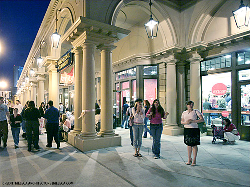
A street-level view of the Cap
As Blair Kamin noted, many Short North businesses have since experienced a dramatic increase in patronage migrating north from downtown. The bridge liners created a seamless, pleasant connection across what would have otherwise been an extremely unpleasant highway: “The cap is so successful that it has changed people’s expectations for highway bridges. The Ohio DOT’s plans for a new highway project include at least one highway bridge with a cap-style treatment. Other bridges will have foundations that allow caps to be built in the future.”
I think Short North-style liners could be effective (and perhaps even profitable) on the bridges that cross the JFX/NEC to connect Station North and Johnston Square to Midtown. Since the five north-south bridges (Maryland, Charles, St. Paul, Calvert, Guilford) and the three east-west bridges (Preston, Biddle, Chase) will eventually require repair or replacement, perhaps it might make sense to add liners to them when that time comes. Of course, the strategy would need to be coordinated with continued infill and adaptive reuse so there'd be a large-enough population to support the activities in the liners.
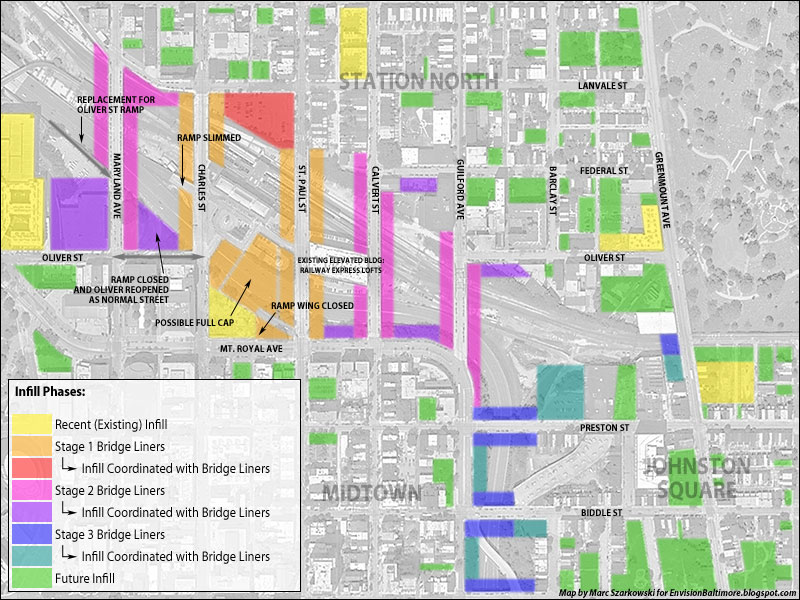
Bridge liners could reconnect Station North and Johnston Square to Midtown
To initially strengthen the connection between Station North and Midtown, the Oliver Street offramp could be relocated to Maryland Avenue (thus allowing Oliver to be reopened as a normal street) and the Charles and St. Paul Street ramps downsized. Then the Charles and St. Paul Street bridges could be lined, and, depending on their success, the Calvert, Guilford, and Maryland bridges could be lined next, followed by the Preston, Biddle, and Chase bridges.
I think liners would extend Midtown's vibrancy across these eight bridges and finally allow meaningful, significant revitalization to spill over into Station North and Johnston Square. The adaptive reuse and infill potential of the many vacant buildings and lots in these two neighborhoods would improve dramatically as land values correspondingly increased.
Dismantling unnecessary sunken corridors
Of course, the cap and liner solutions assume that the sunken corridors in question need to remain intact. But what if they don't? The Highway to Nowhere is a case in point: it was never connected to the interstate highway system, so there's no need to maintain its current dimensions. Building caps or liners would be a waste of money: why dedicate considerable resources to covering something that can just be dismantled?

The Baltimorphosis vision for the Highway to Nowhere.
Dismantling a sunken corridor opens up numerous possibilities for reuse. For example, I prefer the Baltimorphosis proposal for the Highway to Nowhere over the official plans for (partially) capping it: the corridor is ideally suited for the future Red Line, but that doesn't mean its ditchlike configuration need be maintained. There's no reason why the sunken highway couldn't be substantially downsized or eliminated and the reclaimed space used for any number of things, from mixed-use transit-oriented infill to linear parks to some combination thereof.
What about level or embankmented corridors?
Sometimes there are railroad corridors that run either at the same level as the surrounding urban street grid or above it on solid earth embankments (i.e. not on viaducts). Is there any way to fix their border vacuums?
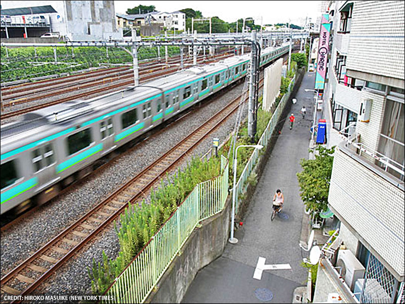
A Tokyo railroad corridor doubles as a bike/pedestrian/shopping lane.
It's possible to punch new streets (or to extend existing dead-ended ones) through embankments to increase the number of connections across/under them. This strategy would probably need to be coordinated with Jane Jacobs' “extraordinarily strong counterforces”: “Population concentration ought to be made deliberately high near borders, the blocks close to them should be especially short and their potential street use extremely fluid, and a mixtures of uses should be abundant (268).” In addition to bringing the mixed-use fabric as close to a railroad corridor as possible, the corridor itself can be improved by incorporating amenities like bike paths and market streets into the right-of-way. This strategy has long been used in Tokyo, and I think it's a strategy US cities ought to investigate.
So, for example, the section of the NEC between Broadway and Orangeville could be turned into a civic asset if an extension of the metro to Bayview and/or the upgrading of MARC service to metro-like frequencies became realities. By lining both sides of the NEC with streets that could double as bike routes and promenades, enclosing these streets with mixed-use infill, and introducing as many cross-streets as possible under the NEC (to allow for small blocks and frequent crossing), it could be turned into one of Kevin Lynch's “seams.” Not only would the corridor offer frequent, convenient metro and/or MARC service (and thus serve as a TOD attractor), it'd double as a leisurely cycling and walking route.
Next time we'll look at solutions for elevated borders (like highway and railroad viaducts), so stay tuned!
This piece originally appeared in the EnvisionBaltimore blog.
For more in-depth coverage:
• Subscribe to Better! Cities & Towns to read all of the articles (print+online) on implementation of greener, stronger, cities and towns.
• Get the March 2013 issue. Topics: City returns to streetcar roots, market shift to urban lifestyles, sprawl lives, Housing boom for the creative class, Retail prospects, Main Street of the Bronx, Green space for transit-oriented project, Multigenerational housing, Architecture of place, New Orleanse freeway redevelopment
• Get New Urbanism: Best Practices Guide, packed with more than 800 informative photos, plans, tables, and other illustrations, this book is the best single guide to implementing better cities and towns.