- Who We Are
- What We Do
- Our Issues
- Our Projects
- Sprawl Retrofit
- Highways to Boulevards
- CNU/ITE Manual
- Health Districts
- The Project for Code Reform
- Lean Urbanism
- LEED for Neighborhood Development
- Missing Middle Housing
- Small-Scale Developers & Builders
- Emergency Response
- HUD HOPE VI
- Rainwater in Context
- Street Networks
- HUD Finance Reform
- Affordable Neighborhoods
- Autonomous Vehicles
- Legacy Projects
- Build Great Places
- Education & Trainings
- Charter Awards
- Annual Congress
- Athena Medals
- Resources
- Get Involved
- Donate
- Public Square
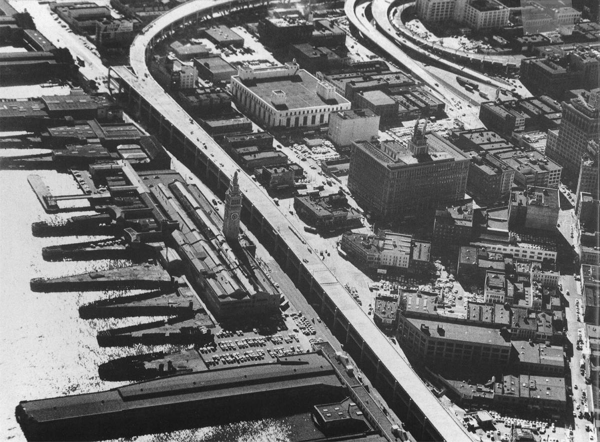
San Francisco's Embarcadero Freeway was originally designed to connect the Bay Bridge and the Golden Gate Bridge but was never completed. The Embarcadero only succeeded in cutting off the city from the waterfront and running long ramps deep into the neighborhood fabric. In the most used sections, traffic on the Embarcadero reached well past 100,000 vehicles per day.
Freeway Removal
The battle to demolish the Embarcadero had been struggling until the 1989 Loma Prieta earthquake. After the earthquake damaged it beyond repair, the city experienced initial traffic congestion but it did not lead to permanent traffic disruptions. The network of streets was able to absorb a large amount of traffic given their previous underused capacity. In addition, annual BART ridership experienced a 15% increase. The scales of public opinion shifted towards removal when residents saw the redevelopment potential and the cost comparisons. Evolving cost projections, which climbed from $15 million for strengthening to $69.5 million for freeway reconstruction, changed the debate in favor of a boulevard--with a final cost less than $50 million.
The Boulevard
Built in 2002, the Boulevard itself was deemed an impressive success from many different angles. Designed by ROMA Design Group as a dynamic multi-use boulevard, it contains two banks of thoroughfare traffic, 3 lanes going in each direction and a streetcar line running down the center. This allows for the accommodation of significant auto traffic, but also gives residents options other than private vehicles.
Economic Development
The area has sprung to life since the freeway demolition. More than 100 acres of land along the waterfront that had once been dominated by the elevated freeway gave way to a new public plaza and waterfront promenade. Dense commercial development has lined the street, housing in the area increased by 51% and jobs have increased by 23%. High profile redevelopments like the old Ferry Building and Pier 1 have continued to transform the waterfront. Similarly, the old industrial South Market area was redeveloped as a dense, mixed-use neighborhood. As of 2006, the large number of recent assessments in the redesigned area pushed the average sale base year to 2000 compared to the citywide average of 1996.


